


AutoGRAPH.Mobile app for iPhone and iPad
Developer: TechnoKom Ltd.
First release : 12 Jun 2013
App size: 110.06 Mb
AutoGRAPH-Mobile is an iOS-client software for users of the internet version of GLONASS/ GPS AVL and personal tracking system “AutoGRAPH”.
The user needs an active account in “AutoGRAPH.WEB” system for application execution.
Press the button “DEMO” on the screen of log-in to get an overview about application`s opportunities.
Main application opportunities:
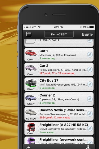
•List of vehicles/personnel with last location positions
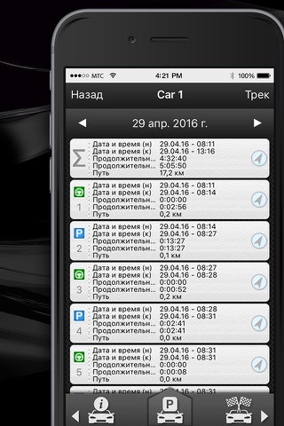
•List of vehicle trips with detailed information displaying about chosen trip
•List of parks and halts
•List of checkpoints and geofences
•List of fuel refills and tank drains
•Vehicle/personnel information
•Vehicle/personnel current position display on the map
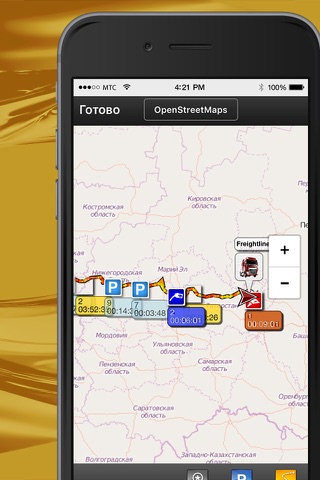
•Track display (traffic route) and events display on the map in set period of time
•Track display (traffic route) and events display of chosen trip on the map
•Vehicle/personnel traffic display in build-in track player on the map
•Flexible and comfortable display interval setting (daily or exact time interval)
•Wide range of maps (expanded with AutoGRAPH.WEB), support vector map.
•Ability of vehicles/personnel dividing by companies
•Multi-level hierarchical folders for transport/personnel grouping in the companies (arranged by departments, business units, teams etc.)
•Current location view of all the vehicles/personnel of chosen company on the map
•Current location view of all the vehicles/personnel from chosen folder on the map
•iPhone / iPod Touch & iPad support
•Retina Display support
About “AutoGRAPH” system:
AVL system “AutoGRAPH” is computer appliance, developed by specialists of Group of companies “TechnoKom” based on state-of-the-industry technologies in the sphere of satellite navigation and also transmission and data processing channels. In the core of the system there is the technology of vehicle or personnel location identification with by using navigation satellite signals of NAVSTAR (GPS) and GLONASS systems.
Field of application of “AutoGRAPH”:
•Personnel of the company and private individuals (children, seniors etc.)
•Corporative and private cars
•Passenger and freight transport
•Agricultural and construction machinery
•Taxi and delivery services
•Alarm services and special-purpose vehicles
•Public services
•Small aircrafts (helicopters, airplanes, agricultural aviation)
•Water (river) transport
•Railway transport
Results after “AutoGRAPH” usage:
•Increase of transport usage and logistic operations effectiveness
•Exact task execution and quick transport/personnel management
•Rapid decrease of costs, connected with fuel stealing, exception of the under-the-counter trips and forced mileage decrease, improprieties and dead-times
•Safety level increase of vehicles, drivers and freight
•Statistics, data reporting and effective planning for managerial staff of all the levels